 Download:
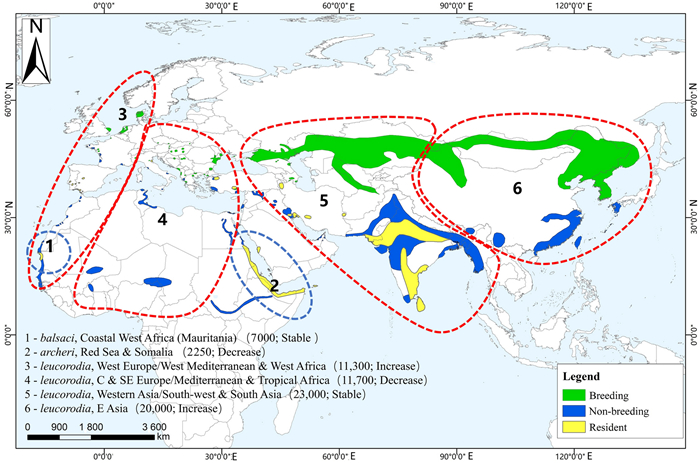
World distribution map of the Eurasian Spoonbill (Platalea leucorodia) geographical population (reproduced from Xi 2021)
Figures of the Article
-
![]() World distribution map of the Eurasian Spoonbill (Platalea leucorodia) geographical population (reproduced from Xi 2021)
World distribution map of the Eurasian Spoonbill (Platalea leucorodia) geographical population (reproduced from Xi 2021)
-
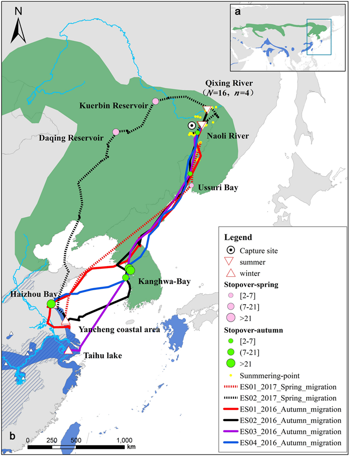
![]() a East Asia map of the breeding (green) and wintering (blue) distribution of the Eurasian Spoonbill. b Enlarged map of the same detailed wintering area in China coast, showing autumn migration routes (N = 4 and stopover sites in green) and spring migration routes (N = 2 and stopover sites in pink). Circles with central black dots indicate capture sites, inverted triangles summering sites, regular triangles wintering sites and yellow dots show areas used during summer. The distribution data of the Eurasian Spoonbill are derived from Xi (2021)
a East Asia map of the breeding (green) and wintering (blue) distribution of the Eurasian Spoonbill. b Enlarged map of the same detailed wintering area in China coast, showing autumn migration routes (N = 4 and stopover sites in green) and spring migration routes (N = 2 and stopover sites in pink). Circles with central black dots indicate capture sites, inverted triangles summering sites, regular triangles wintering sites and yellow dots show areas used during summer. The distribution data of the Eurasian Spoonbill are derived from Xi (2021)
-
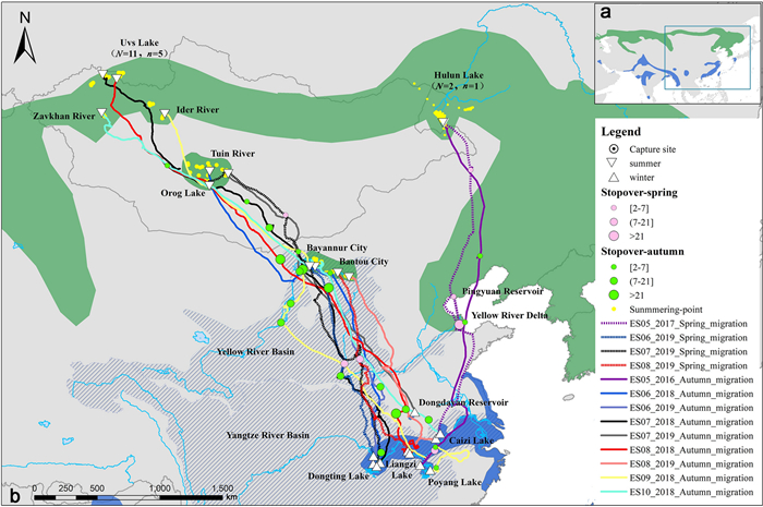
![]() a East Asia map of the breeding (green) and wintering (blue) distribution of the Eurasian Spoonbill. b Enlarged map of the same detailed wintering inland in China, showing the dichotomy between birds breeding in western Mongolia (autumn migration routes (N = 8); spring migration routes (N = 3)) and that caught at Hulun Lake, Inner Mongolia (autumn migration routes (N = 1); spring migration routes (N = 1)). Circles with central black dots indicate capture sites, inverted triangles summering sites, regular triangles wintering sites and yellow dots show areas used during summer, the black cross-hatched area represents the Yellow River Basin and the Yangtze River Basin. The distribution data of the Eurasian Spoonbill are derived from Xi (2021)
a East Asia map of the breeding (green) and wintering (blue) distribution of the Eurasian Spoonbill. b Enlarged map of the same detailed wintering inland in China, showing the dichotomy between birds breeding in western Mongolia (autumn migration routes (N = 8); spring migration routes (N = 3)) and that caught at Hulun Lake, Inner Mongolia (autumn migration routes (N = 1); spring migration routes (N = 1)). Circles with central black dots indicate capture sites, inverted triangles summering sites, regular triangles wintering sites and yellow dots show areas used during summer, the black cross-hatched area represents the Yellow River Basin and the Yangtze River Basin. The distribution data of the Eurasian Spoonbill are derived from Xi (2021)
-
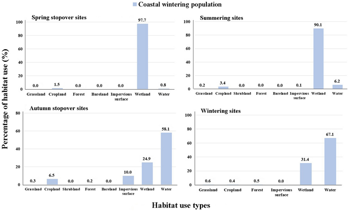
![]() Habitat use of the Eurasian Spoonbill wintering along the coast of China in their spring migration stopover sites, summering sites, autumn migration stopover sites and wintering sites
Habitat use of the Eurasian Spoonbill wintering along the coast of China in their spring migration stopover sites, summering sites, autumn migration stopover sites and wintering sites
-
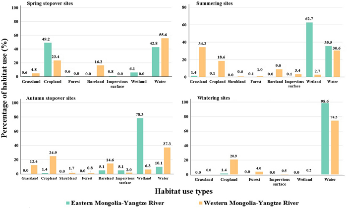
![]() Habitat use of the Eurasian Spoonbill wintering on the Yangtze River in their spring migration stopover sites, summering sites, autumn migration stopover sites and wintering sites
Habitat use of the Eurasian Spoonbill wintering on the Yangtze River in their spring migration stopover sites, summering sites, autumn migration stopover sites and wintering sites
-
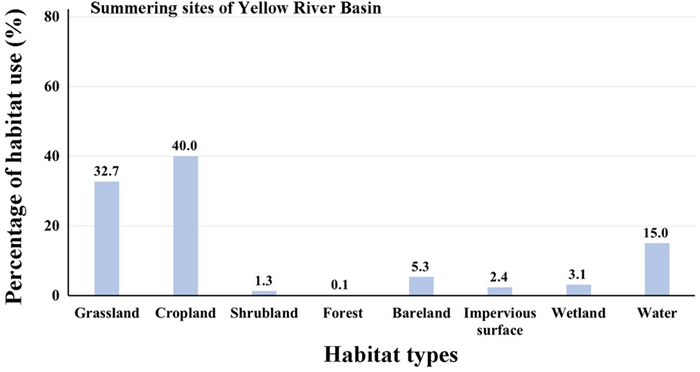
![]() Habitat use of western Mongolia-Yangtze River individuals (n = 2) in the summering area of the Yellow River Basin
Habitat use of western Mongolia-Yangtze River individuals (n = 2) in the summering area of the Yellow River Basin
-
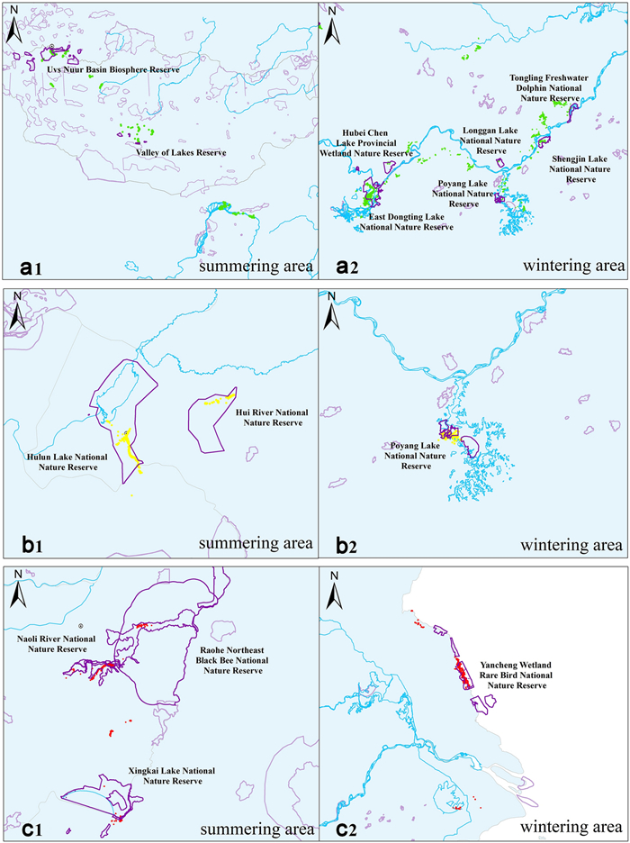
![]() Maps showing the current extent of protected areas (outlined in purple, with those used by birds shown in darker purple) used by telemetry tagged Eurasian Spoonbills (indicated by different coloured dots) marked at the three discrete breeding areas. Left maps show summer distributions, right maps show the situation in winter in China. Top maps (a1 and a2) show the summering and wintering areas of birds that summered in western Mongolian, middle maps (b1 and b2) show the summering and wintering areas of birds that summered in Inner Mongolia, and lower maps (c1 and c2) show the summering and wintering areas of birds that wintered in Jiangsu coast, China. Green dots represent individual positions of birds marked in western Mongolia; yellow dots represent the bird marked in Inner Mongolia; red dots represent those wintering along the Jiangsu coast of China
Maps showing the current extent of protected areas (outlined in purple, with those used by birds shown in darker purple) used by telemetry tagged Eurasian Spoonbills (indicated by different coloured dots) marked at the three discrete breeding areas. Left maps show summer distributions, right maps show the situation in winter in China. Top maps (a1 and a2) show the summering and wintering areas of birds that summered in western Mongolian, middle maps (b1 and b2) show the summering and wintering areas of birds that summered in Inner Mongolia, and lower maps (c1 and c2) show the summering and wintering areas of birds that wintered in Jiangsu coast, China. Green dots represent individual positions of birds marked in western Mongolia; yellow dots represent the bird marked in Inner Mongolia; red dots represent those wintering along the Jiangsu coast of China
Related articles
-
2022, 13(1): 100007. DOI: 10.1016/j.avrs.2022.100007
-
2021, 12(1): 49. DOI: 10.1186/s40657-021-00284-3
-
2021, 12(1): 35. DOI: 10.1186/s40657-021-00270-9
-
2020, 11(1): 8. DOI: 10.1186/s40657-020-00193-x
-
2019, 10(1): 22. DOI: 10.1186/s40657-019-0160-y
-
2018, 9(1): 16. DOI: 10.1186/s40657-018-0111-z
-
2017, 8(1): 31. DOI: 10.1186/s40657-017-0089-y
-
2015, 6(1): 26. DOI: 10.1186/s40657-015-0031-0
-
2013, 4(2): 170-183. DOI: 10.5122/cbirds.2013.0012
-
2012, 3(2): 113-117. DOI: 10.5122/cbirds.2012.0014


 Email Alerts
 RSS Feeds